| |
|
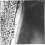 |
| Aerial survey photographs of Miami Beach between Lummus Park to Government Cut. |
|
|
| Aerial survey photographs of Miami Beach between Lummus Park to Government Cut. |
|
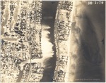 |
| Aerial views of oceanfront buildings in North Miami Beach. Views of estates, hotels, and green areas |
|
|
| Aerial views of oceanfront buildings in North Miami Beach. Views of estates, hotels, and green areas |
|
|
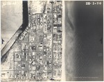 |
| Aerial views of City of Surfside, Florida, and North Miami Beach islands and buildings |
|
|
| Aerial views of City of Surfside, Florida, and North Miami Beach islands and buildings |
|
![[1935] The Typhoon 1935](http://dpanther.fiu.edu/sobek/content/AA/00/00/01/03/00001/TYPHOON1935thm.jpg) |
|
| [1935] The Typhoon 1935 |
|
|
![[1936] The Typhoon 1936](http://dpanther.fiu.edu/sobek/content/AA/00/00/01/04/00001/AA00000104pdfthm.jpg) |
|
| [1936] The Typhoon 1936 |
|
![[1938] The Typhoon 1938](http://dpanther.fiu.edu/sobek/content/AA/00/00/01/05/00001/AA00000105pdfthm.jpg) |
|
| [1938] The Typhoon 1938 |
|
|
![[1938/1997] Miami Beach Drum and Bugle Corps, 1938, and the demolition of the Water Tower on First and Alton Road, 1997](http://dpanther.fiu.edu/sobek/content/FI/14/10/33/00/00001/936_1_000thm.jpg) |
| Miami Beach Drum and Bugle Corps, 1938, and the demolition of the Water Tower on First and Alton Road, 1997 |
|
|
| [1938/1997] Miami Beach Drum and Bugle Corps, 1938, and the demolition of the Water Tower on First and Alton Road, 1997 |
|
![[1939] The Typhoon 1939 Miami Beach High School.](http://dpanther.fiu.edu/sobek/content/AA/00/00/01/07/00001/927_4_001thm.jpg) |
| The Typhoon 1939 Miami Beach High School. |
|
|
| [1939] The Typhoon 1939 Miami Beach High School. |
|
|
![[1938/1940] Miami Beach High School Band, Drum and Bugle Corps, 1938-1943](http://dpanther.fiu.edu/sobek/content/AA/00/00/01/16/00001/3020_1_000thm.jpg) |
| Miami Beach High School Band, Drum and Bugle Corps, 1938-1943 |
|
|
| [1938/1940] Miami Beach High School Band, Drum and Bugle Corps, 1938-1943 |
|
![[1940] The Typhoon 1940](http://dpanther.fiu.edu/sobek/content/AA/00/00/01/08/00001/TYPHOON1940thm.jpg) |
|
| [1940] The Typhoon 1940 |
|
|
![[1941] The Typhoon 1941](http://dpanther.fiu.edu/sobek/content/AA/00/00/01/10/00001/1941_TYPHOONthm.jpg) |
|
| [1941] The Typhoon 1941 |
|
![[1941] Aerial views of Miami Beach's Bay side and islands on Biscayne Bay, June 1941](http://dpanther.fiu.edu/sobek/content/MB/00/00/13/71/00017/1371_7_10_000thm.jpg) |
| Aerial views of Miami Beach's Bay side and islands on Biscayne Bay, June 1941 |
|
|
| [1941] Aerial views of Miami Beach's Bay side and islands on Biscayne Bay, June 1941 |
|
|
![[1941] Aerial view of man-made islands and causeways, 1941](http://dpanther.fiu.edu/sobek/content/MB/00/00/13/71/00007/1371_7_10_000thm.jpg) |
| Aerial view of man-made islands and causeways, 1941 |
|
|
| [1941] Aerial view of man-made islands and causeways, 1941 |
|
![[1941] Aerial views of Miami Beach between Government Cut and Normandy Isle, 1941](http://dpanther.fiu.edu/sobek/content/MB/00/00/13/71/00008/1371_8_10_000thm.jpg) |
| Aerial views of Miami Beach between Government Cut and Normandy Isle, 1941 |
|
|
| [1941] Aerial views of Miami Beach between Government Cut and Normandy Isle, 1941 |
|
|
![[1941] Aerial view of Miami Beach oceanfront buildings and bay side islands, 1941](http://dpanther.fiu.edu/sobek/content/MB/00/00/13/71/00009/1371_9_000thm.jpg) |
| Aerial view of Miami Beach oceanfront buildings and bay side islands, 1941 |
|
|
| [1941] Aerial view of Miami Beach oceanfront buildings and bay side islands, 1941 |
|
![[1941] Aerial view of the Di Lido, Rivo Alto and Belle Islands](http://dpanther.fiu.edu/sobek/content/MB/17/05/26/00/00001/1371_7_10_000thm.jpg) |
| Aerial view of the Di Lido, Rivo Alto and Belle Islands |
|
|
| [1941] Aerial view of the Di Lido, Rivo Alto and Belle Islands |
|
|
![[1941] Aerial view of the Di Lido, Rivo Alto and Belle Islands](http://dpanther.fiu.edu/sobek/content/MB/17/05/26/00/00002/1371_7_11_000thm.jpg) |
| Aerial view of the Di Lido, Rivo Alto and Belle Islands |
|
|
| [1941] Aerial view of the Di Lido, Rivo Alto and Belle Islands |
|
![[1941] Aerial view of the north end of Di Lido, Rivo Alto and Belle Islands](http://dpanther.fiu.edu/sobek/content/MB/17/05/26/00/00003/1371_7_12_000thm.jpg) |
| Aerial view of the north end of Di Lido, Rivo Alto and Belle Islands |
|
|
| [1941] Aerial view of the north end of Di Lido, Rivo Alto and Belle Islands |
|
|
![[1941] Aerial view of Biscayne Bay north of the Venetian Islands](http://dpanther.fiu.edu/sobek/content/MB/17/05/26/00/00004/1371_7_13_000thm.jpg) |
| Aerial view of Biscayne Bay north of the Venetian Islands |
|
|
| [1941] Aerial view of Biscayne Bay north of the Venetian Islands |
|
![[1941] Aerial view of Fisher Island and Norris Cut](http://dpanther.fiu.edu/sobek/content/MB/17/05/26/00/00005/1371_7_1_000thm.jpg) |
| Aerial view of Fisher Island and Norris Cut |
|
|
| [1941] Aerial view of Fisher Island and Norris Cut |
|

