|
|
| |
|
 |
|
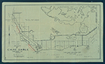
| Map of Cape Sable. |
|
![[1913] Records relating to land in the Cape Sable region](http://dpanther.fiu.edu/sobek/content/ML/00/04/01/25/00001/file1thm.jpg) |
| Records relating to land in the Cape Sable region |
|
|
| [1913] Records relating to land in the Cape Sable region |
|
|
![[1920] Map showing special road and bridges, Cape Sable District, Monroe County, 1920](http://dpanther.fiu.edu/sobek/content/AM/00/99/00/01/00001/001a_thm.jpg) |
| Map showing special road and bridges, Cape Sable District, Monroe County, 1920 |
|
|
| [1920] Map showing special road and bridges, Cape Sable District, Monroe County, 1920 |
|
![[1920] Records relating to Ingraham Highway and Royal Palm Hammock (Royal Palm State Park)](http://dpanther.fiu.edu/sobek/content/ML/00/17/04/49/00001/file10thm.jpg) |
| Records relating to Ingraham Highway and Royal Palm Hammock (Royal Palm State Park) |
|
|
| [1920] Records relating to Ingraham Highway and Royal Palm Hammock (Royal Palm State Park) |
|
|
![[1928] Map made for the U.S. Coast and Geodetic Survey of Cape Sable : East Cape to Shark River, April 12, 1928](http://dpanther.fiu.edu/sobek/content/AM/00/99/00/02/00001/002a_thm.jpg) |
| Map made for the U.S. Coast and Geodetic Survey of Cape Sable : East Cape to Shark River, April 12, 1928 |
|
|
| [1928] Map made for the U.S. Coast and Geodetic Survey of Cape Sable : East Cape to Shark River, April 12, 1928 |
|
|
|

