| |
|
 |
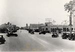
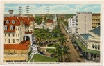
| Miracle Mile street view of with the Colonnade Building to the right. Business District, Coral Gables, Florida |
|
|
| Miracle Mile street view of with the Colonnade Building to the right. Business District, Coral Gables, Florida |
|
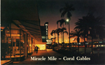 |
| Nighttime view of Miracle Mile. Business District , Coral Gables, Florida |
|
|
| Nighttime view of Miracle Mile. Business District , Coral Gables, Florida |
|
|
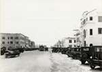 |
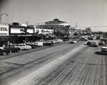
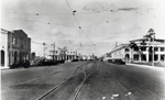
| Streetcar and cars on Business District , Coral Gables, Florida |
|
|
| Streetcar and cars on Business District , Coral Gables, Florida |
|
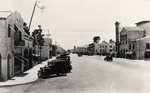 |
| Ponce de Leon Boulevard looking South. Coral Gables, Florida |
|
|
| Ponce de Leon Boulevard looking South. Coral Gables, Florida |
|
|
 |
| Renuart Realty Co. Business District, Coral Gables, Florida |
|
|
| Renuart Realty Co. Business District, Coral Gables, Florida |
|
 |
| Streetcar lines. Business District, Coral Gables, Florida |
|
|
| Streetcar lines. Business District, Coral Gables, Florida |
|
|
 |
| Brickell Avenue, Millionaire's Row, Miami, Fla. |
|
|
| Brickell Avenue, Millionaire's Row, Miami, Fla. |
|
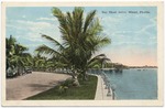 |
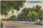
| Bay Shore Drive, Miami, Florida |
|
|
| Bay Shore Drive, Miami, Florida |
|
|
 |
| Second Avenue, north from Flagler Street, Miami, Fla. |
|
|
| Second Avenue, north from Flagler Street, Miami, Fla. |
|
 |
| South Miami Ave. at Deering Estate, Miami Fla. |
|
|
| South Miami Ave. at Deering Estate, Miami Fla. |
|
|
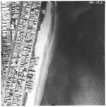 |
| Aerial survey photographs of Miami Beach between Lummus Park to Government Cut. |
|
|
| Aerial survey photographs of Miami Beach between Lummus Park to Government Cut. |
|
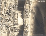 |
| Aerial views of oceanfront buildings in North Miami Beach. Views of estates, hotels, and green areas |
|
|
| Aerial views of oceanfront buildings in North Miami Beach. Views of estates, hotels, and green areas |
|
|
 |
| Aerial views of City of Surfside, Florida, and North Miami Beach islands and buildings |
|
|
| Aerial views of City of Surfside, Florida, and North Miami Beach islands and buildings |
|
 |
| The Story of the Bond Election: Paving and Sidewalks |
|
|
| The Story of the Bond Election: Paving and Sidewalks |
|
|
![[nd] Riviera Plaza Apartments](http://dpanther.fiu.edu/sobek/content/FI/24/02/05/41/00001/FI24020541_00001_1994_370_732thm.jpg) |
|
| [nd] Riviera Plaza Apartments |
|
![[1880] View of a busy street](http://dpanther.fiu.edu/sobek/content/FI/19/09/11/25/00001/MM00032289_00001thm.jpg) |
|
| [1880] View of a busy street |
|
|
![[1897-12] Street Scene of Key West, Florida](http://dpanther.fiu.edu/sobek/content/FI/DT/00/00/08/00066/FIDT000008_IMG_6433thm.jpg) |
| Street Scene of Key West, Florida |
|
|
| [1897-12] Street Scene of Key West, Florida |
|
![[1900/1909] 900 block of Whitehead and Truman Streets](http://dpanther.fiu.edu/sobek/content/MM/00/00/12/06/00001/51297_MM00001206_thm.jpg) |
| 900 block of Whitehead and Truman Streets |
|
|
| [1900/1909] 900 block of Whitehead and Truman Streets |
|
|
![[1908/1911] Ocean Avenue, Boynton Beach, Florida, c. 1910](http://dpanther.fiu.edu/sobek/content/FI/19/06/04/40/00001/FI19060440_00001_A0013-28-016thm.jpg) |
| Ocean Avenue, Boynton Beach, Florida, c. 1910 |
|
|
| [1908/1911] Ocean Avenue, Boynton Beach, Florida, c. 1910 |
|
![[1909] Caroline street after the hurricane](http://dpanther.fiu.edu/sobek/content/MM/00/00/08/59/00001/51087_MM00000859_thm.jpg) |
| Caroline street after the hurricane |
|
|
| [1909] Caroline street after the hurricane |
|

